Here’s Your First Look at the Map for Frequent, High-Quality Denver Transit
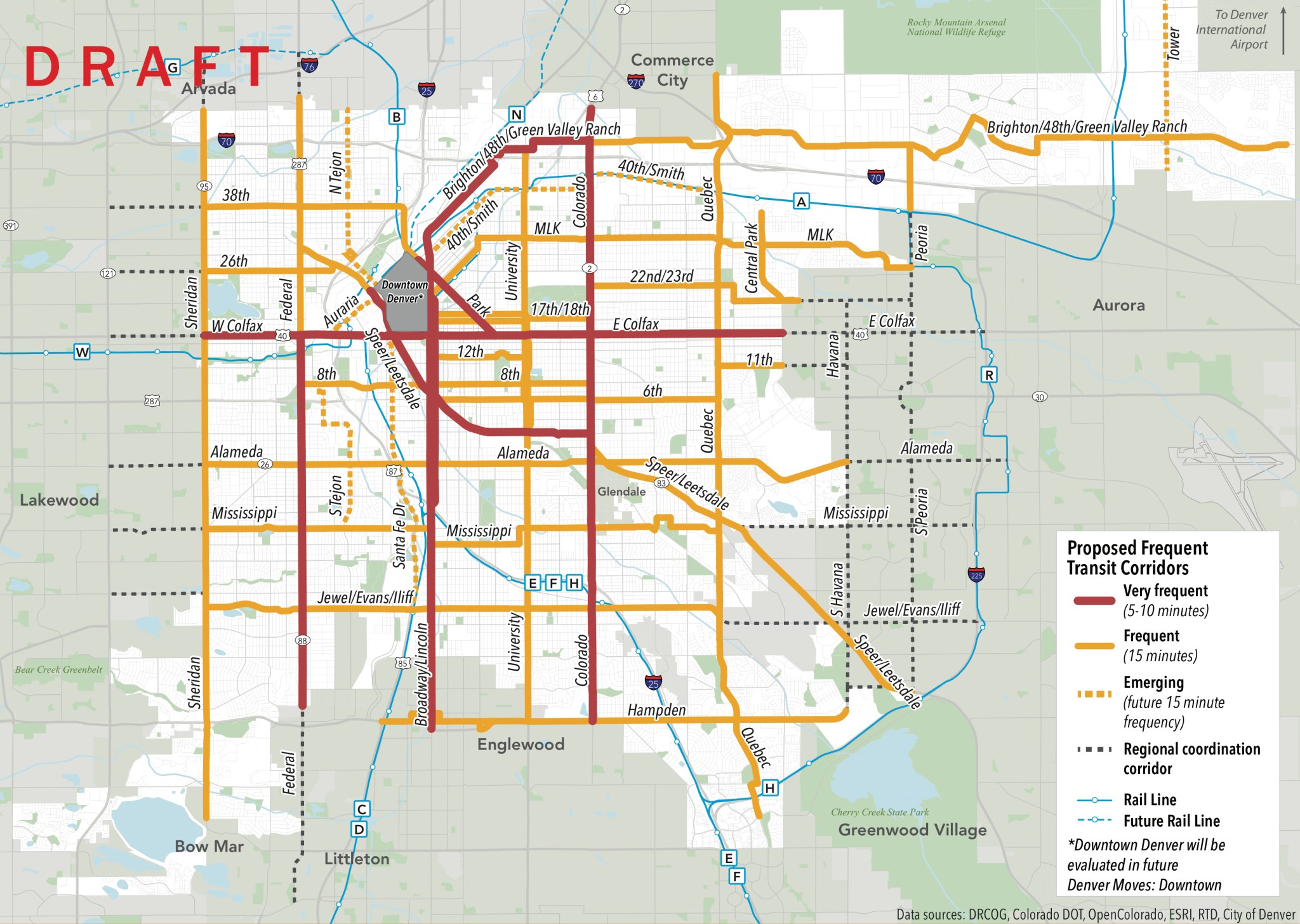
Last week, City Hall’s Denveright transit initiative unveiled the preliminary map for a high-frequency transit network, a grid of service that arrives at least every 15 minutes.
An all-day grid of frequent service is the foundation of any high-quality transit network. The idea is that buses and trains should come so often that people don’t have to worry about schedules — riders can count on transit coming every few minutes throughout the day. The grid pattern makes transfers easy and gives people confidence that transit will get them where they need to go.
Currently only 30 percent of Denverites live within an easy walk of a bus or rail line that comes every 15 minutes or less. The proposed frequent grid would change that.
As part of the Denveright planning process, city transportation planners and consultants identified seven corridors for “very frequent” service, or transit that comes every five to 10 minutes (the red lines on the map above). Some specifics may be tweaked after the city incorporates feedback from the Denveright task force, made up of members of the public, but travel demand makes these streets a high priority:
- Colfax Avenue
- Colorado Boulevard
- Federal Boulevard (south of Colfax)
- Broadway/Lincoln Street
- Brighton Boulevard/48th Avenue/Green Valley Ranch Boulevard (west of Colorado)
- Speer Boulevard/Leetsdale Drive (west of Colorado)
- Park Avenue
On the 21 streets highlighted in orange, meanwhile, buses and trains would arrive at least every 15 minutes.
Key to implementation will be changes like bus lanes and other measures that prioritize transit on Denver streets. Without the ability to bypass car congestion, buses and surface rail won’t be able to reliably meet these schedules for frequent service. So the Denveright planning team has also ranked streets according to the level of transit priority they view as necessary.
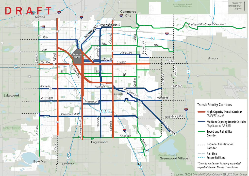
Streets marked in red are “high capacity” corridors where the full suite of bus rapid transit or light rail treatments will be needed to keep transit riders moving. A BRT line is already in the works for Colfax, and the city has studied redesigning Federal, Speer/Leetsdale, and Broadway/Lincoln for better transit. But this is the first time the city has publicly considered prioritizing transit on Colorado Boulevard and Park Avenue, the latter of which carries zero buses today.
“Medium capacity” corridors, shown in blue, could improve service with treatments like bus lanes and traffic signals that give buses a head start at intersections.
“Speed and reliability” corridors call for smaller improvements like off-board fare payment and better bus stops with real-time arrival info.
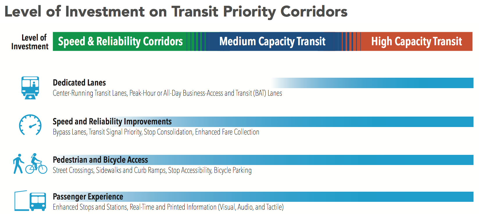
Here’s a visual breakdown of what’s included in each category:
Planners don’t have dollar figures to attach to these proposals yet. Funding and implementation strategies will be covered in the last section of the plan, due out in the first quarter of next year.
If the Hancock administration expects to significantly increase the share of people taking transit and reduce solo driving by 2030, a frequent grid will be essential — and in order to make a difference the plan will need proper funding and swift implementation.
Streetsblog has migrated to a new comment system. New commenters can register directly in the comments section of any article. Returning commenters: your previous comments and display name have been preserved, but you'll need to reclaim your account by clicking "Forgot your password?" on the sign-in form, entering your email, and following the verification link to set a new password — this is required because passwords could not be carried over during the migration. For questions, contact tips@streetsblog.org.


