Blueprint Denver Task Force Sets Its Sights on Tackling Car Dependence
How will Denver manage its growth while remaining affordable and without getting overrun by traffic?
The people charged with revamping Blueprint Denver, the city’s transportation and land use plan, began to answer that question Thursday. It was the first meeting of the 33-member task force, which is comprised of residents with expertise in transportation, development, business, and neighborhood organizing.
A few challenges are clearly at the top of the task force’s list. Denver is too dependent on cars, and it needs to address its affordable housing shortage.
“We are the ‘it’ place right now,” said Community Planning and Development Director Brad Buchanan. “And that means that in 20 years, I don’t know what it’s gonna be like, but there’s gonna be a whole lot more of us here. We have mobility challenges, affordable housing challenges… we have all those things to think about.”
When the task force was asked what challenges the city faces, car dependence and its negative effect on neighborhoods rose to the top. Concerns ranged from the barren sea of parking lots making Arapahoe Square unwalkable to the lack of basic infrastructure like good sidewalks in Westwood.
“Despite the progress we’ve made, we still haven’t quite got that hierarchy of pedestrians, bikes, and transit at the top of the list in this auto-driven city,” said Tim Baldwin of local firm Rocky Mountain West Transit and Urban Planning.
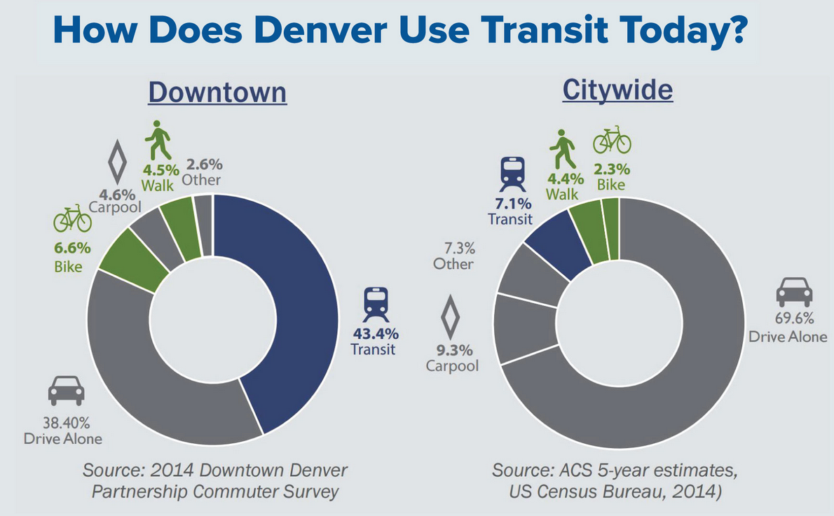
In 2015, driving solo still accounted for 70 percent of all trips in Denver, according to census data. Between 2002 and 2012, the share of commutes by foot, bike, or transit increased a dismal 0.1 percent, according to Denveright consultants.
So how will revamping Blueprint Denver, which was first released in 2002, lead to a shift in transportation behavior?
The original Blueprint document shaped development by prescribing “areas of change” and “areas of stability.” It is responsible for the mixed-use development in Denver’s walkable neighborhoods, but it also left room for plenty of car-oriented neighborhoods. Now planners can revise the old blueprint with an eye toward concentrating development in areas with good transit service, for example.

People won’t start riding transit or biking without bold investments from the Hancock administration that make those modes faster, more convenient, and less stressful.
“I’m amazed when I look at those streets like Colorado Boulevard, Broadway, and Colfax, which are huge, wide streets,” said Joe Vostrejs of Larimer Associates, which helped develop Larimer Square and Union Station. “There’s no bike lanes on those, there’s no streetcars on them. There’s right of way to work with, and they’re long, which provides super opportunities to fix those streets and improve the neighborhoods that are around them.”
“We’ve made amazing progress on bike infrastructure,” said Parry Burnap, a member of the Mayor’s Bicycle Advisory Committee. “However, I will say it’s been inconsistent and opportunistic and disconnected and confusing to motorists. So the big challenge and opportunity is to go system-wide and be methodical about it.”
If you want to get involved in this effort to shape Denver’s streets, you can. The task force is taking cues from the Denveright website, where you can imark up a city map with your ideas about what needs to change on a street or in a neighborhood. You can also submit comments and apply to be part of the “Denveright Community Think Tank,” a “forum for community leaders to share thoughts and ideas on important topics that relate to all four plans.”
Streetsblog has migrated to a new comment system. New commenters can register directly in the comments section of any article. Returning commenters: your previous comments and display name have been preserved, but you'll need to reclaim your account by clicking "Forgot your password?" on the sign-in form, entering your email, and following the verification link to set a new password — this is required because passwords could not be carried over during the migration. For questions, contact tips@streetsblog.org.


