Denver Has a Plan for Safer Westwood Streets, Now Hancock Needs to Fund It
Getting around Westwood in southwest Denver without a car is not safe, let alone pleasant or convenient. You have to contend with wide, high-speed streets and thin, crumbling sidewalks — where sidewalks exist at all. Motorists zoom down Federal, Sheridan, Kentucky, Alameda, and Morrison Road with little regard for the lives of people pushing strollers or walking to the bus stop.
Now a new neighborhood plan from Community Planning and Development — the first in 30 years — aims to make Westwood’s streets safe for walking and biking and convenient for transit riders [PDF].
Few neighborhoods in the city would benefit more from improvements to walking, biking, and transit. About 60 percent of Westwood households have children, and 35 percent live below the poverty line, compared to 20 percent citywide — indicating that a higher than average share of people in this predominantly Latino neighborhood depend on travel options other than private cars. Westwood is dense, too, with 16 residents per acre, compared to an average of six citywide.
Below are some highlights from the transportation sections of the plan (which also delves into housing, parks, and how to keep the neighborhood affordable). There are a lot of good ideas here, but in the end, it’s still just a plan. Once City Council passes it later this summer, it will be up to Mayor Michael Hancock to fund these recommendations.
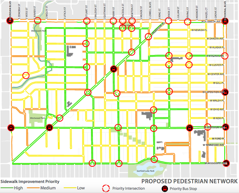
WALKING
Recognizing that “over the past century we have engineered walking out of our daily lifestyle,” the city identifies dangerous intersections and recommends street design techniques to calm traffic and expand pedestrian space, as well as basic sidewalk repairs. Among the recommendations:
- Curb extensions, chicanes (brief curved sections on otherwise straight streets), and traffic circles to engineer safer driving habits into the street.
- Narrower travel lanes on Federal and Alameda.
- Colored, decorated, and/or textured crosswalks that grab drivers’ attention, plus signs indicating pedestrian crossings.
- All-way stops for vehicles at intersections with heavy pedestrian traffic.
- Safety improvements on walking routes to schools will be prioritized.
- More street lighting, tree lawns, and benches.
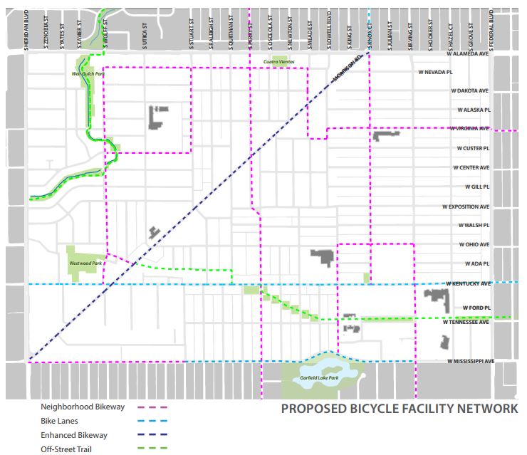
BIKING
Westwood’s streets should be easy to bike “for a wide-range of novice and experienced cyclists,” the city says. Planners float the idea of turning the striped bike lane on Morrison Road into a protected bike lane once ridership increases, but why wait? The way to increase ridership is to provide a comfortable place to bike.
The plan also recommends:
- “Neighborhood bikeways” — streets that prioritize bike traffic by slowing down cars while letting cyclists proceed with as few stops as possible — on Wolff Street, Perry Street, Nevada Place, and Mississippi Avenue.
- A bike lane on Kentucky Avenue.
- Signal timing to prioritize bikes, bike boxes (waiting areas in front of of the car queue at lights), and directional markings for bicyclists at high-traffic intersections.
- Neighborhood programs that “remove barriers to biking” like bike clinics and paths to bike ownership through partnerships with nonprofits and businesses.
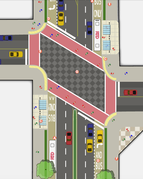
TRANSIT
The plan’s biggest idea is creating a transit-only lane on Federal Boulevard, along with signals that prioritize buses at intersections. Good first-and-last-mile connections — the routes to and from transit stops — are also prominent in the Westwood plan, but are largely covered in the pedestrian and bicycle sections.
Planners also recommend:
- Covered waiting areas, benches, and real-time bus information at high-traffic bus stops.
- Programs to encourage more employer-sponsored RTD passes.
- Compact development that complements transit.
- Programs to increase ride-sharing, pop-up transit services like Bridj.
Streetsblog has migrated to a new comment system. New commenters can register directly in the comments section of any article. Returning commenters: your previous comments and display name have been preserved, but you'll need to reclaim your account by clicking "Forgot your password?" on the sign-in form, entering your email, and following the verification link to set a new password — this is required because passwords could not be carried over during the migration. For questions, contact tips@streetsblog.org.


