BikeDenver Releases Map Showing Bike Lanes to Nowhere
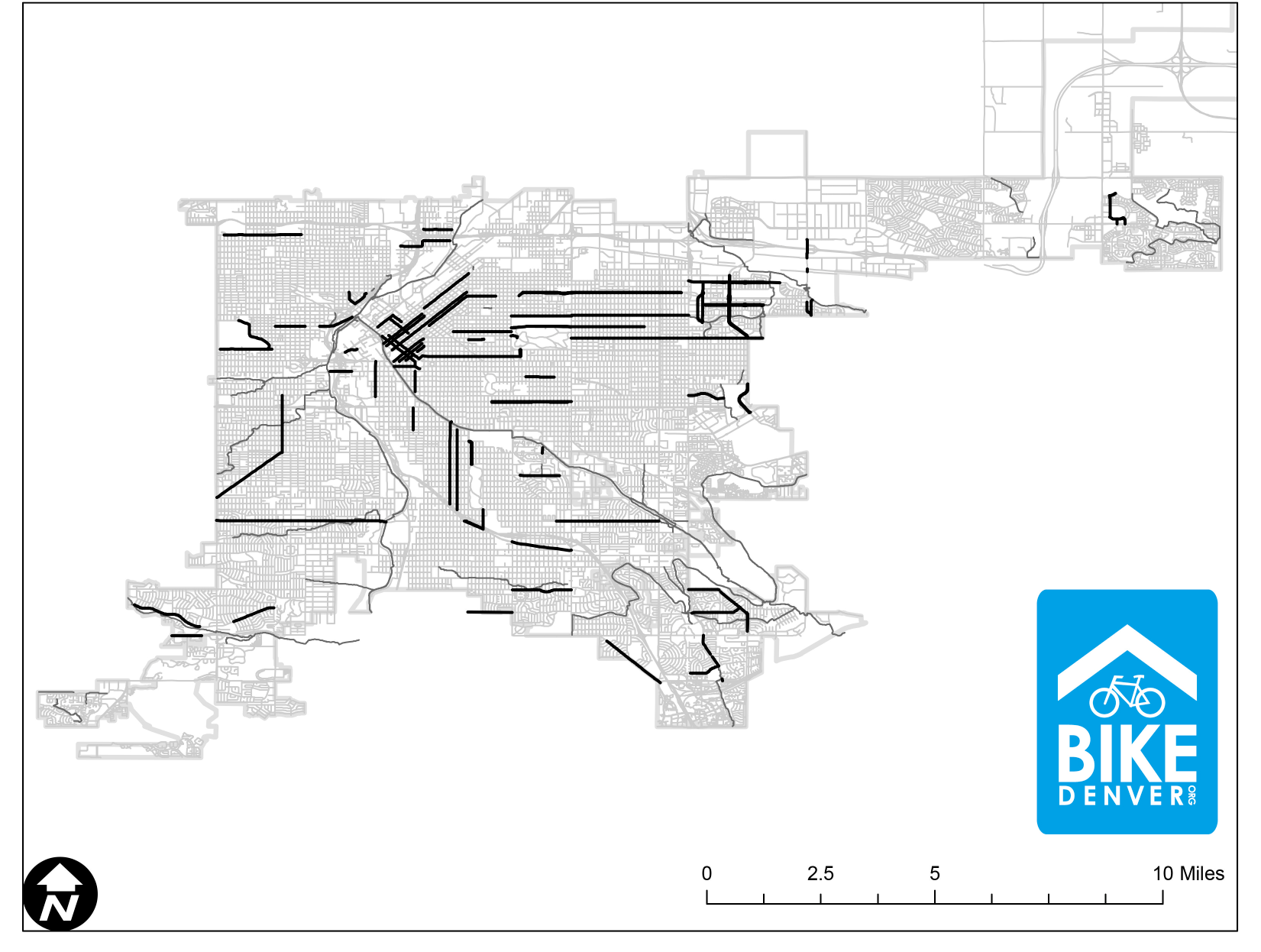
People who depend on Denver’s bike network to get around are tossed from calm bike lanes into chaotic streets too often because of sporadic, fragmented infrastructure. It’s a familiar feeling for riders, but seeing the gaping voids mapped above is striking, even cringeworthy.
BikeDenver released the map yesterday, inspired by a Washington Post article that mapped the disconnects in DC, Seattle, Miami, and Boston. Author Emily Badger summed up the problems well:
Bike commuting throughout the city is often like this: cobbled together out of a bit of bike lane here, an unprotected shoulder there, a scrap of sharrow and some silent pleas that cars won’t run you over. Bike lanes occasionally appear and vanish multiple times on the same street. Sometimes they last just a few hundred feet. It feels as if someone striped the city with dozens of quarter-mile commutes in mind.
What’s the first thing you notice about Denver’s network? The scarcity of north-south connections stands out. And yet the Department of Public Works and Mayor Michael Hancock are lagging on building one (just one!) along the Broadway corridor.
Or maybe you noticed all the bike lanes that are just floating without connecting to any other bike lane. Even Denver’s best bike facility, the 15th Street protected bike lane, ends abruptly and strands you in a left-turn lane next to fast-moving traffic.
Or how about the bike lane deserts east of Colorado Boulevard or in the northeast and southwest sections of the city? Imagine a Swiss cheese grid like this for cars — it would never fly.
Denver has so many bike lanes to nowhere because the city only striped them to placate bike advocates, or to get the city onto a top 10 list. That’s changing. For example, DPW no longer counts sharrows as a legitimate bike facility (they’re not included on BikeDenver’s map, either). And bike advocates and DPW have proposed a better bike network as part of the “Enhanced Bikeways” plan. But there’s a chasm between those goals and today’s streets.
The idea that people on bikes are lucky to get any infrastructure at all pervades Denver (see here, here, and here). When you look at this map, bike riders don’t seem so lucky.
Streetsblog has migrated to a new comment system. New commenters can register directly in the comments section of any article. Returning commenters: your previous comments and display name have been preserved, but you'll need to reclaim your account by clicking "Forgot your password?" on the sign-in form, entering your email, and following the verification link to set a new password — this is required because passwords could not be carried over during the migration. For questions, contact tips@streetsblog.org.


