Antiquated to Elevated: Hello from Alameda Falls!
This is part four of the Streetsblog Denver series covering the Elevate Denver General Obligation bond. Every Tuesday, we’ll be looking at and dissecting different biking, walking, and transit upgrades across the city. We’ll explore the planning aspects behind key projects in addition to considering how these changes will affect the lives of people in the communities where they are located. Read parts one, two and three.
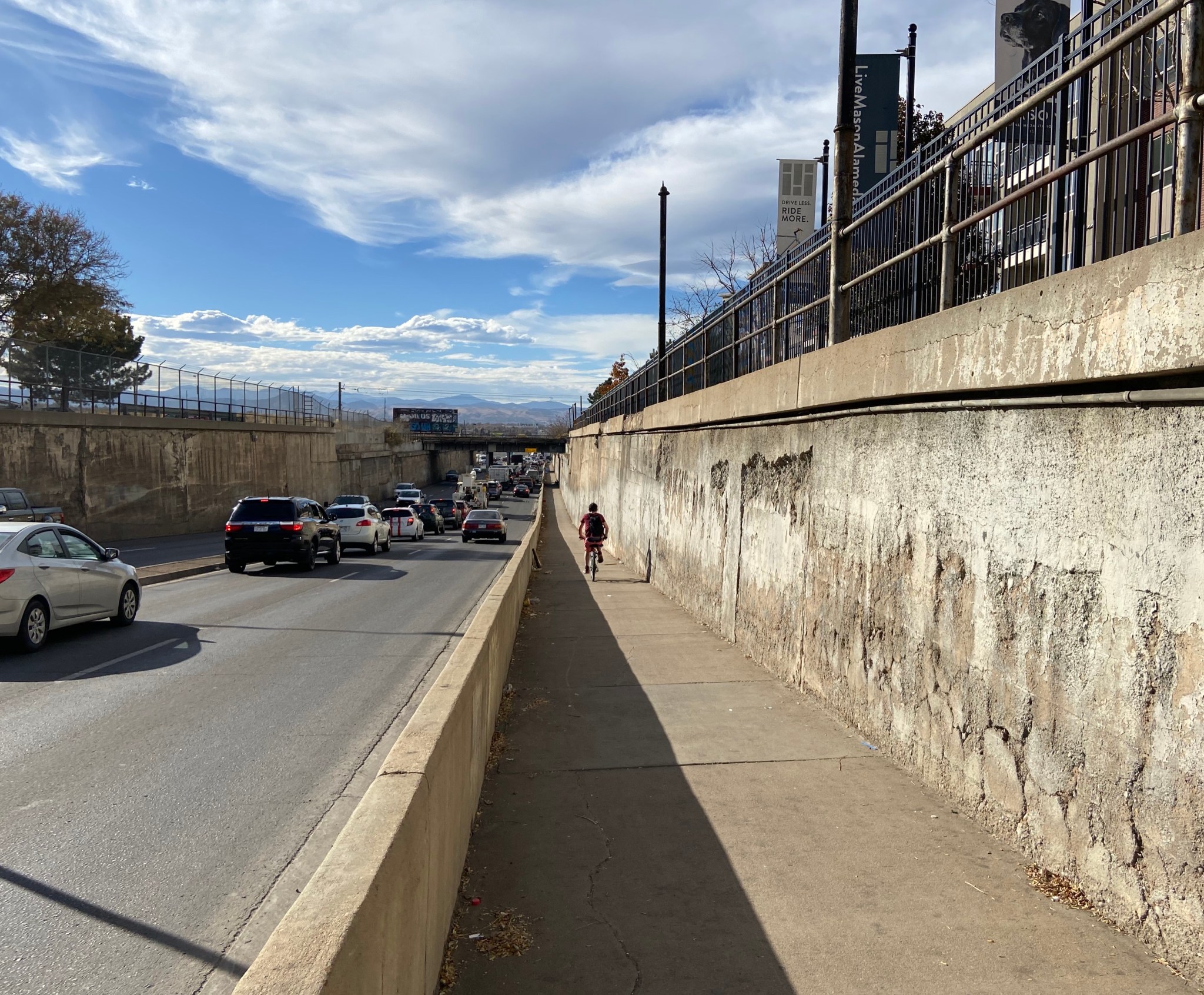
One of Minneapolis’s largest tourist attractions is the beautiful Minnehaha waterfall, visited by tens of thousands each year. At an impressive 53 feet tall, it is one of the largest urban waterfalls in the country. Denver boasts an urban waterfall of its very own, although it’s not a sanctioned tourist site. If you’re (un)lucky enough to be crossing under the railroad on Alameda between Santa Fe and Cherokee on a rainy day, you too will see gallons and gallons of water spill down, past the decaying bridges and onto the narrow sidewalk and street, carrying large amounts of debris with it. This cascade is a huge safety hazard for all people walking, biking and otherwise traveling under this crossing daily, which is why it was included in the Elevate Denver bond funding package, seeking to dry up what locals have dubbed “Alameda Falls.”
The bridges that carry and spill the water also carry trains over Alameda. The easternmost bridge was taken down in 2018 after being deemed unsafe for train use, and the remaining bridges remain in desperate need of repair. Beneath the spans is one of the busiest east-west thoroughfares in the city, Alameda Ave. People in cars rumble past the rusty trusses holding up some of the most heavily-used railways in the city, operated by the RTD Light Rail, Union Pacific and BNSF. The area hosts non-car traffic as well: the north side of Alameda has a narrow multi-use sidewalk which carries hundreds of bicyclists and pedestrians each day. For communities in this part of the city and people passing through, this bottleneck is an important rail crossing, with the nearest alternatives being more than a mile away. Along with replacing these decaying rail bridges, the City is looking to transform the Alameda corridor into a safer place for all on the road.

The aging supports and bridge deck carrying the Light Rail
“It’s an awful spot for everyone,” Kacie Warner, the Program Manager of the Athmar Park Living Coalition, told Streetsblog in an interview. As a frequent biker and walker down Alameda, she noted that she has “had many close calls there.” In a spot that is so vital for people living in Southwest Denver, she affirmed that this upgrade would be hugely beneficial for those in and out of her neighborhood. According to Warner, drivers “are not looking for people walking and people on their bikes … residents are using this area and having a lot of difficulties.”
Tangier Nadean Barnes Wright, who served on the committee that helped decide the bond projects and is a former resident of Athmar Park, knows just how important this upgrade is to this community as well. “It’s critical for people’s everyday lives,” she told Streetsblog. In fact, Barnes Wright recounted that “this project received the most in-person public comment of any of the other bond projects … That’s how big of a deal it was to people on both sides of I-25.”
Piep Van Heuen, Director of Government Relations at Bicycle Colorado*, recalls seeing Athmar Park residents bring plastic bags filled with rubble to a public meeting, urging Denver elected officials to fix the area. Each bag was filled with fragments from the concrete walls of the underpass, collected at Alameda Falls that very same day.
Beneath the crumbling walls, the current sidewalk carrying bikers and walkers is too narrow by the City’s own standards. In the Denver Moves Plan, the City defined the minimum width for a shared sidewalk—meaning one is used for people walking and biking—as 8 feet. Along Alameda between Cherokee and Santa Fe, the current sidewalk width falls short at a mere 7 feet 5 inches wide. While bicycles are allowed to ride in the right vehicular lane on Alameda, the high speeds and masses of people driving discourage many from doing so. Furthermore, the century-old trestles in the middle of the roadway bottleneck the area even more. While there are concrete “Jersey Barriers” separating car traffic from people walking and biking, the tightly-packed area makes this stretch feel particularly crowded, unpleasant and unsafe.
Warner and many others have been complaining about this problem zone for quite a long time, and while they feel that District 7 Councilperson Jolon Clark has been understanding and receptive, there are many aspects to this project that make it particularly complex. For one, dealing with the railroads always makes for difficult logistics. BNSF and Union Pacific are requiring that the railroad cannot be out of service for more than 8-12 hours total, not a sufficient amount of time to implement a significant bridge repair or rebuild. As a result, the City will have to reroute the railroads on new bridges, either temporarily or permanently, to demolish the existing structures. This will require the City to acquire new land on the north side of Alameda. Despite the high cost of working around these complications, the City is determined to have this project go forward.
In constructing the new bridges, the City plans to widen the street to make room for the addition of a sidewalk on the south side and a widened northern sidewalk. These improvements will help make it safer for the thousands of people who pass through this tight corridor every day. Though the full bridge replacement cost is projected to be nearly $50 million, around $7 million has been allocated in the GO bond package to go towards resurfacing the current north side wall and improving the existing sidewalk. Initial construction is expected to begin in 2022, and with it, people in the Southwest parts of the city will finally have a safer way to reach their places of work, schools and recreational activities thanks to Elevate Denver bond funding. In addition, these safety improvements could encourage new Light Rail ridership with enhanced safety protections for multi-modal travelers reaching stations without the use of a private vehicle.
Residents west of Santa Fe hope that this underpass improvement will connect them with transit to other parts of the city. Warner noted that “this project would very much help provide connectivity to the Light Rail for our neighborhood and other West Denver neighborhoods.” While many people across I-25 can see and hear the Light Rail zoom by from their houses, getting there without a car is a significant and occasionally dangerous trek. Many people flock to this part of town for its community feel and proximity to the city center, and residents hope this project will make them feel that close without a car. “We have so many barriers, it doesn’t feel like we are connected.”

A view of traffic and the narrow sidewalk going through the underpass
* Streetsblog Denver is published by Bicycle Colorado and Denver Streets Partnership
Get Streetsblog Denver’s weekday headlines delivered to your inbox. Sign up for our e-mail digest
Streetsblog has migrated to a new comment system. New commenters can register directly in the comments section of any article. Returning commenters: your previous comments and display name have been preserved, but you'll need to reclaim your account by clicking "Forgot your password?" on the sign-in form, entering your email, and following the verification link to set a new password — this is required because passwords could not be carried over during the migration. For questions, contact tips@streetsblog.org.


