Google Maps Now Includes Lime Bikes and Scooters in Transit Directions

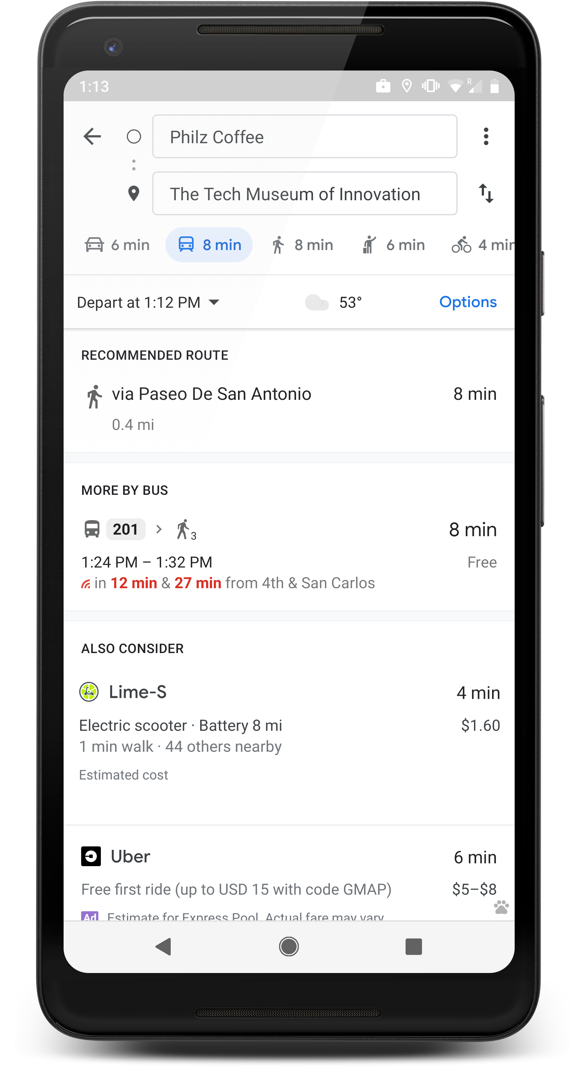
Google Maps will now show you nearby Lime scooters, pedal bikes and e-bikes in its transit directions. The new feature is available in 80 cities, including Denver, which adds another privately run mobility option to the dominant mapping app.
Lime joins two other Silicon Valley companies, Uber and Lyft, within the transit directions tab of the Google Maps app. The move highlights how tech companies are racing to become the go-to app when planning a trip — and how many mobility options Google excludes.
When you plan a transit trip with Maps, you won’t see publicly supported bike-share services like Denver B-Cycle or Lime’s private competitors like JUMP dockless bikes or scooters from other startups. But the new feature could help more people get around without a car. Google offered an example of how it might make public transportation more useful.
“You just got off your train and you have seven minutes to get to your first meeting on time — but it’ll take you 15 minutes to walk the rest of the way,” the company wrote in a blog post. “You don’t have time to walk, your bus is delayed and the next ridesharing vehicle isn’t set to arrive for another 10 minutes. So close, yet so far.”
Buses and trains often get close to where people want to go, but not close enough for them to stop using their cars. Both Google and Lime pitch this new feature as a solution to public transit’s first- and last-mile problem.
To find Lime vehicles, plug a destination into the Google Maps app for Android or iOS and hit the transit directions tab. When Lime vehicles are nearby, they will show up within the available options. Whether you use a Lime vehicle for the entire trip or combine it with public transportation, the app will estimate how long your trip will take and how much it will cost.
In the United States, startups and established tech companies are rushing to become the first app people open when planning a trip, often emphasizing trips in cars in congested areas where local governments struggle to manage traffic.
In recent weeks, Uber started showing transit options in Denver through a partnership with the Regional Transportation District. But bus options often cannot be seen without actively scrolling to the bottom of multiple Uber options, where users then see estimated trip times that highlight Uber’s speed advantage. Transit, a competing mobile trip-planning app, offers a broader range of mobility choices, including JUMP bikes and Denver B-cycle vehicles, but does not allow payments.
Google’s piecemeal approach shows just how far America has to go to link all forms of transit into one user interface. Several countries in Europe have issued monthly fare passes that work with all forms of mobility, creating a seamless mobile app for bike share, car share, scooters, subways and buses. Proponents call the approach MaaS, or Mobility as a Service.
Google Maps started showing Lime vehicles in December when the feature rolled out to 13 cities. Now users in 80 cities around the world can use the service. Google says the number of cities will continue to expand.
Better walking. Better biking. Better transit. Support the nonprofit mission of Streetsblog Denver. Give $5 per month.
Streetsblog has migrated to a new comment system. New commenters can register directly in the comments section of any article. Returning commenters: your previous comments and display name have been preserved, but you'll need to reclaim your account by clicking "Forgot your password?" on the sign-in form, entering your email, and following the verification link to set a new password — this is required because passwords could not be carried over during the migration. For questions, contact tips@streetsblog.org.


