Watch Denver’s Historic Streetcar Network Grow Rapidly — Then Disappear

As the city overhauls its transit system, Denver’s historic streetcar network holds lessons for today.
Ryan Keeney, the same Denverite who brought us this insane visualization of space dedicated solely to parking downtown, created this interactive map that illustrates the legacy of streetcars and how they shaped Denver back in the day.
[youtube https://www.youtube.com/watch?v=6QJ4y2qAb0w]
“They built streetcar lines that allowed the footprint of the city to grow larger,” said Keeney, a geographic information systems masters student at the University of Denver who’s focusing on urban planning . “Once they built a line, they would build a tightly knitted street grid along the line and build houses around it.”
Not just houses — stores, schools, doctors’ offices, you name it. The streetcar system led to flourishing, compact neighborhood hubs — think South Pearl Street — where people could walk to their daily needs, or take transit to destinations further away.
That’s how the city grew until the middle of the last century. In 1950, Denver dug up the last of its streetcar tracks to make way for the automobile.
Just as the streetcar lines shaped neighborhood development in the first part of the 20th century, automobiles shaped the city in the second. But while streetcars encouraged close-knit, walkable places, cars encouraged sprawling, unwalkable development. City officials bulldozed buildings to pave parking lots, and neighborhoods became more spread out, less compact.
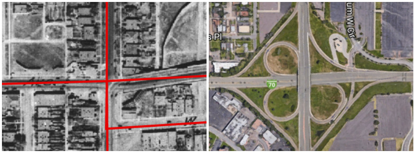
Compare a 1933 overlay of Keeney’s map with a modern one. Clusters of homes, shops, and services surrounded the intersection of Colfax and Federal in 1933. Zoom in on the intersection today, and there’s a highway cloverleaf interchange and parking lots.
“I think that if we want to shift the mode share away from single occupancy vehicles, as Mayor Hancock set out as a goal in the State of the City address, I think we need to invest more in intra-city transit,” Keeney said. “I think another approach is trying to figure out how we encourage commercial developments in neighborhoods that are somewhat under-served, so that everybody in the city proper can walk to the sorts of services they need in their daily lives, like a grocery store.”
Keeney found a 1915 survey that documented travel in and out of downtown on one day. More than half of travelers — 51 percent — used a streetcar, and 38 percent walked.
The point is not that Denver should recreate the old streetcar network — investments in bus service can deliver more bang for the buck — but to apply lessons from the streetcar era to our modern context. Denver used to be a city with more compact mixed-use development, frequent local transit, and less parking — these remain the building blocks a walkable, transit-oriented city.
To meet his own goals for transit, walking, and biking, Hancock will have to move the city toward a future that, in some ways, captures what made Denver work so well in the past.
Streetsblog has migrated to a new comment system. New commenters can register directly in the comments section of any article. Returning commenters: your previous comments and display name have been preserved, but you'll need to reclaim your account by clicking "Forgot your password?" on the sign-in form, entering your email, and following the verification link to set a new password — this is required because passwords could not be carried over during the migration. For questions, contact tips@streetsblog.org.


