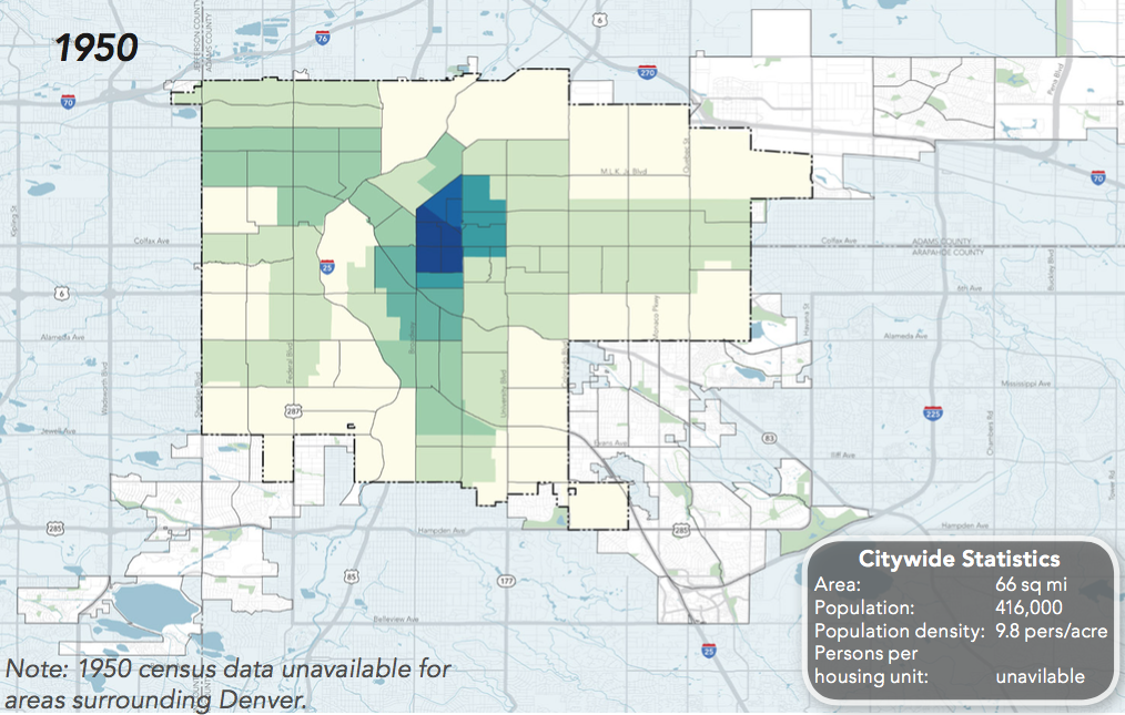
Lots of Denver Neighborhoods Were Denser in 1950 Than They Are Today
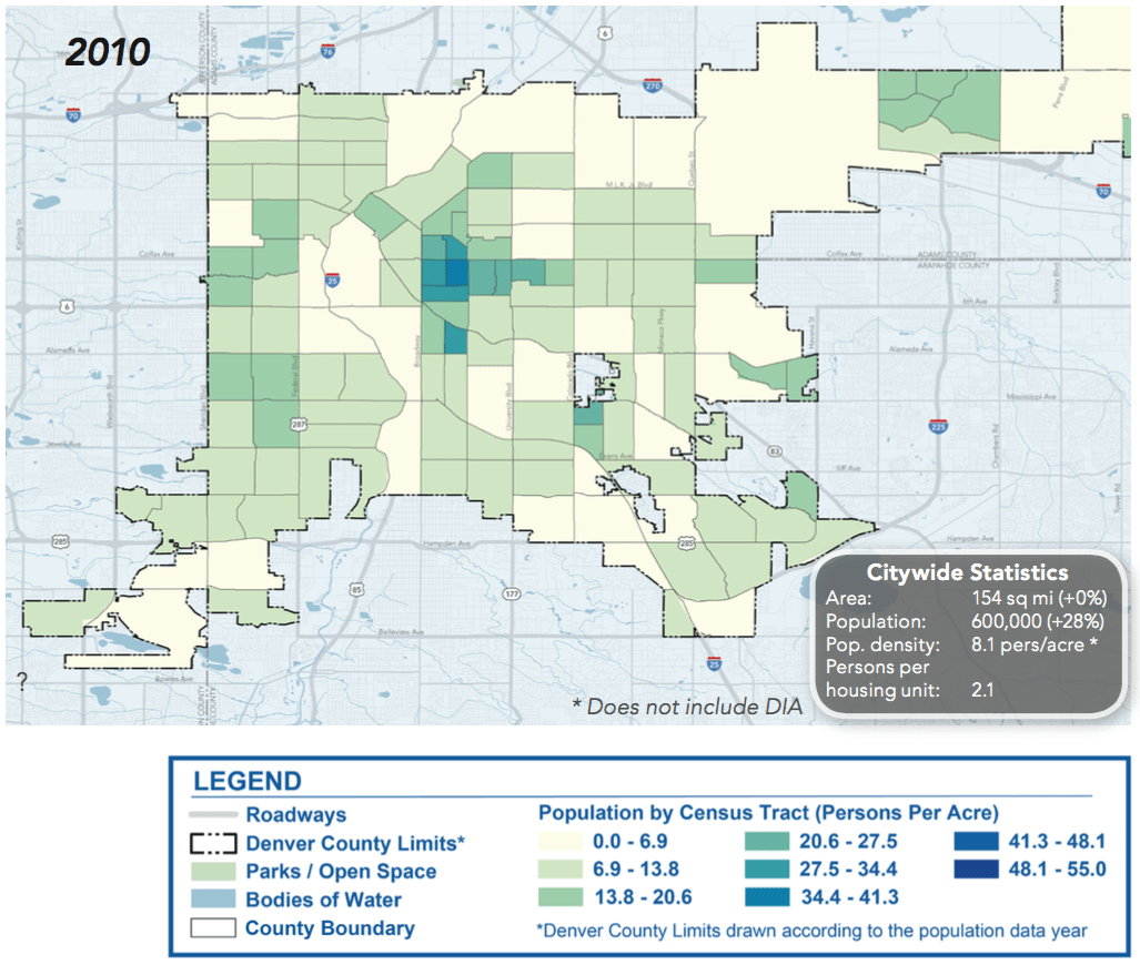
When people complain about development that adds more homes and people, or push absurd ideas about closing the Front Range to newcomers, here’s something to keep in mind: A lot of Denver’s neighborhoods were denser in 1950 than in 2010.
According to new data out of the city’s Denveright planning initiative, more people lived in many downtown and near-downtown neighborhoods in the 50s — including fast-developing places like the Central Business District, Capitol Hill, Highland, Jefferson Park and part of Five Points — because Denver’s streetcar system and land use allowed it. More homes and destinations closer together meant more people could easily walk, bike, or ride transit where they needed to go.
When city and state decision makers began planning almost solely for private automobiles and building the enormous highways and parking lots needed to accommodate mass motoring, the streetcar system was decimated. Walkable neighborhoods declined as city dwellers fled to sprawling suburbs.
“Now in the last 10 to 20 years, we’re seeing more people move back into the city and repopulating these neighborhoods, but we haven’t necessarily caught up with the transportation network to move these people around the city in an efficient manner,” said David Gaspers, principal planner with Denver Community Planning and Development. “Because maybe you can start to have that increased density, but with everyone still having their own individual car, it really becomes a problem.”
In many places (but not all), there were more buildings 67 years ago, in addition to more people. “In downtown in particular, a lot of the population that you would’ve seen in 1950 were in multi-family or mixed-use buildings that have been torn down in the 50s and 60s to accommodate parking lots and the auto-oriented nature of development at that time,” Gaspers said. “So there’s a lot of housing stock that was eliminated in those couple of decades.”
In other words, for example, there’s no conspiracy to “take” on-street parking spots from people by adding homes without dedicated parking spaces. Adding homes and more transportation choices is a logical move for a growing city trying to make room for more people. Denver has accommodated higher densities before, and it can do so again.
Gaspers and CPD hope the revision of Blueprint Denver, the city’s land use and transportation plan, will shape development and transportation in a way that helps people live car-free if they choose to. Two major goals have emerged in the past six months: Improving the function of streets to move more people (as opposed to more cars), and location efficiency, or making places closer together so long trips aren’t necessary.
“It’s about urban design and how we actually integrate our land use decisions and transportation decisions to actually make a great city,” Gaspers said. “And you could argue that focusing so much infrastructure on automobiles and accommodating for those automobiles has caused a conflict there. If we’re gonna continue to see a population increase in Denver, we’re gonna have to figure out how to move more people in more efficient ways.”
Streetsblog has migrated to a new comment system. New commenters can register directly in the comments section of any article. Returning commenters: your previous comments and display name have been preserved, but you'll need to reclaim your account by clicking "Forgot your password?" on the sign-in form, entering your email, and following the verification link to set a new password — this is required because passwords could not be carried over during the migration. For questions, contact tips@streetsblog.org.


