The Future of Our Streets and Neighborhoods Hinges on “Denveright”
As more people come to Denver, will car traffic overrun streets and neighborhoods, or will the city steer its growth to encourage more trips by transit, biking, and walking?
Under the banner “Denveright,” Mayor Michael Hancock and his administration launched four new plans Thursday that could shape Denver for decades to come. Most relevant to streets and transportation are Denver’s first blueprint for intra-city transit, a master plan for a quality pedestrian network, and a land use plan to integrate development with sustainable transportation. The administration also launched a plan for city parks and recreation.
“This is culture-altering,” Hancock told Streetsblog. “It’s just gonna take time for people to get out of the habit of being in cars, and the desire and need to be in cars.”
The Hancock administration expects the plans to be finished between 18 months and two years from now, following an extensive public feedback process. The end result will be a set of policy priorities to improve transit, create a seamless pedestrian network, and shape development so Denver’s lightning-fast growth creates walkable neighborhoods, not car-choked streets.
Of course, acting on those priorities is what matters in the end, and we’ve seen with the underfunded citywide bike plan that City Hall doesn’t necessarily follow up on implementation. But with “Denveright” the city is setting the right goals and laying the groundwork for sustainable growth.
Hancock said he wants city planners and residents to think big, without worrying about financial constraints. “I think it’s important that you don’t put guardrails on the community,” he said. “I don’t want you to think about cost. Obviously we have limitations of what we can do as a city, but what I want you to do is dream — imagine what you want this place to be and what it will take to get there, and then let us back into the resource side of it later on.”
While the video makes Denveright seem light and fluffy, it’s going to be a huge undertaking if the city takes it seriously. Thursday’s launch provided some insight into the nascent plans. Here’s what we know so far.
Denver’s First Intra-City Transit Strategy, a.k.a. “Denver Moves: Transit”
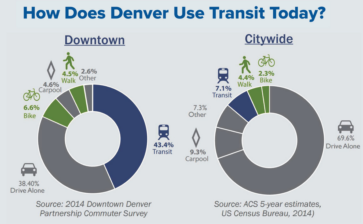
Until now, Denver’s transit network has been in the hands of the Regional Transportation District, resulting in good connections between Denver and its suburbs but lackluster service within the city itself. Denver’s transit needs go beyond what RTD, a regional agency, will ever realistically provide. The transit plan aims to give the city proper the attention it deserves.
One inspiration for Denver’s transit overhaul could be Houston, said Jeffrey Tumlin, a transportation planner at Nelson Nygaard. There, transit planners created a much more useful network of frequent bus routes and extended weekend service — without increasing the transit budget. Ridership increased after just a few months.
“When you look at an RTD map, it’s really hard — I’m a transit professional and I can’t figure out how the transit system works,” Tumlin told Streetsblog. “So having a customer-oriented lens and not just focusing on your current customer, those are things that Denver cares about more than RTD, because transit success is a prerequisite for continued economic development in Denver. Denver cannot add more jobs and housing without making its transportation system more space efficient. Which means that Denver’s economic future is completely dependent on a more successful RTD.”
The Nexus of Development and Transportation, a.k.a. “Blueprint Denver”
In 2002, Denver planners created “Blueprint Denver.” The document shaped how neighborhoods grew by establishing “areas of change” and “areas of stability.” The plan shaped a lot of the mixed-use development you see in walkable neighborhoods today — but it also led to the construction of a lot of unwalkable, car-oriented neighborhoods. Under Denveright, planners will revisit and revise the old blueprint with an eye toward concentrating development in areas with good transit service.
“You have to match your land use strategy with your transportation strategy, which is one of my favorite aspects about this planning process in Denver — that it’s asking both of these questions at the same time,” Tumlin said. “And it also recognizes that the best transportation plan is always a good land use plan.”
A Comprehensive Strategy for Walking Infrastructure, a.k.a “Denver Moves: Pedestrians and Trails”
Information on this one is scarce, but we do know that advocates and City Council members are working on a way to fund a complete sidewalk network, and the city will hire a full-time pedestrian planner for the first time this year. From the Denveright website:
The Denver Moves: Pedestrians & Trails plan will examine how we can make walking a viable and primary mobility choice for people to conduct their daily lives and access Denver’s outstanding recreational resources. The plan will work to improve our streets and streetscapes for pedestrians and cyclists, to connect them to Denver’s robust off-street trail network.
“If we don’t design cities where 10,000 steps can happen easily, then we are dooming our citizens,” Tumlin said. “Where walking is unrelentingly delightful, all transportation modes start and end with a walking trip. Do not ever sacrifice a quality pedestrian experience for the efficiency of other modes of transportation.”
The Denveright website is worth checking out. It includes a feature that lets mark up a city map with your ideas about what needs to change on a street or in a neighborhood. You can also submit comments and apply to be part of the “Denveright Community Think Tank,” a “forum for community leaders to share thoughts and ideas on important topics that relate to all four plans.”