Does the Plan for I-25 and Broadway Do Enough for Biking and Walking?
“The ‘Midtown’ of Denver.” That’s how a 95-page blueprint from various city agencies envisions the area around RTD’s I-25 and Broadway Station.
The plan makes some exciting promises: Walkable, bikeable, transit-friendly streets and bridges would reconnect neighborhoods divided by I-25, the South Platte River, train tracks, and wide, fast roads. And planners want to create a new mixed-use neighborhood with housing, plazas, offices, retail space, and parks anchored by the light rail station.
Will Denver pull it off? Funding, as is often the case, is a big question mark. RTD’s addiction to pairing its transit investments with lots of parking could also spoil the vision of multi-modal streets. When it’s time to build, the whims of private developers may not align with the city’s goals.
Some residents last night said the plan doesn’t go far enough for walking and biking — they wanted guarantees that all bridges will provide car-free connections. Still, if actualized, the plan promises a thorough makeover. The whole document is massive and worth a read [PDF], but here’s a breakdown.
“Transformative Projects”
David Gaspers, the project manager with Community Planning and Development, said the plan identifies “transformational projects that are important enough that they need to be talked about separately.” Building these projects depends on whether private developers agree with them down the road, and whether funding is available. Here’s a partial list:
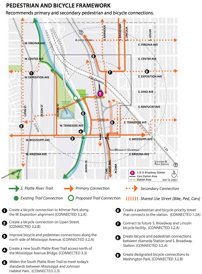
- Bridges over the railroad tracks and the river that connect people to the station from east and west of I-25. Some will be just for people walking and biking, but some will allow cars in addition to providing paths for pedestrians and bicyclists.
- A “signature shared-use street” parallel to South Broadway between Kentucky and Mississippi. Planners see the street as a promenade that prioritizes walking and biking over vehicular traffic.
- A new, narrow street for people walking, biking, and possibly driving would extend from West Exposition Avenue across the railroad tracks and connect Athmar Park to the new area.
- A redesigned Mississippi Avenue would include a biking and walking path that connects South Broadway to Santa Fe, signals that prioritize pedestrian and bicycle crossings, and a “wide bicycle and pedestrian connection” along the seven-lane Mississippi bridge.
- Plazas built “at a human scale” under the I-25 overpass and in other areas around the site that would include designated bike paths.
- Exposition Avenue would become the “gateway” to the station for both people and cars, with a bikeway that’s separated from traffic, and wider sidewalks with a buffer from the street.
Undermining a Place for People With Over 1,200 Parking Spots
RTD’s light rail station would anchor this “multimodal hub” — which made RTD’s absence from last night’s public workshop, the project’s third, remarkable. In fact, the transit agency isn’t even listed as a participant in the blueprint. (The partner agencies are Community Planning and Development, Denver Public Works, and the Parks and Recreation Department). This despite I-25 and Broadway being Denver’s most important transit hub behind Union Station.
“RTD should be here, because I have a lot of questions for them,” said Luchia Brown, president of Baker Historic Neighborhood Organization.
Given the area’s metamorphosis from industrial sprawl into a dynamic group of neighborhoods, one question is why RTD would maintain the station’s 1,248 parking spaces. That’s the plan right now — to keep I-25 and Broadway Station as a park-n-ride. That type of thinking flagrantly opposes the plan’s goals by encouraging driving and car-oriented design. Car owners can park for free or for cheap at the station, which is right off the highway.
Next Steps
The I-25 and Broadway plan is technically still a draft. The final version will go to the Denver Planning Board for a vote on February 17. Until then, planners say residents can still influence the blueprint by commenting.