Why WalkDenver’s Tactical Urbanism Projects Matter
Denver is just beginning to recover from decades of car-first planning. Making the city walkable will take big changes, like a legitimate way to fund a sidewalk network and a much more aggressive approach to reducing traffic deaths and serious injuries on our streets. Campaigns like those are marathons. They take years to unfold and change the city. To get in shape for the big race, it helps to win some sprints too — and make immediate improvements visible on the ground.
Enter pedestrian advocates WalkDenver. You may know the them from the recent Reimagine West Colfax event, in which they worked with merchants to transform the street with temporary parklets, crosswalks, bulb-outs, and bike lanes. Advocates and business owners expect the demo to spark permanent changes to the neighborhood.
It’s a perfect example of how WalkDenver’s “tactical urbanism” projects show residents and decision makers that streets can be transformed to connect people on foot to transit, parks, businesses, and one another.
WalkDenver has had some practice. Today the organization was recognized by ioby (in our backyards), an online platform for neighborhood-led projects, and TransitCenter, which funds urban transportation projects, for Great Paths, a pedestrian wayfinding project WalkDenver implemented last year in Northwest Denver’s Jefferson Park neighborhood.
For Great Paths, WalkDenver installed 50 signs that guided people to destinations around the business district and displayed how much time it takes to get there on foot. Want to get to the aquarium? It’s a 12-minute walk that way. The library? Seven minutes this way.
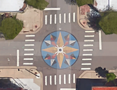
The project’s location made sense. It’s accessible by transit and growing fast, but also burdened by streets like the daunting “cloverleaf” intersection at Colfax and Federal. The project included a high-visibility mural painted on the asphalt at the intersection of West 25th and Eliot aimed at slowing down traffic and improving the pedestrian experience.
The wayfinding signs have gone over well with pedestrians and business owners, WalkDenver told ioby and TransitCenter, especially people from outside the neighborhood who tend to have trouble orienting themselves.
Streetsblog has migrated to a new comment system. New commenters can register directly in the comments section of any article. Returning commenters: your previous comments and display name have been preserved, but you'll need to reclaim your account by clicking "Forgot your password?" on the sign-in form, entering your email, and following the verification link to set a new password — this is required because passwords could not be carried over during the migration. For questions, contact tips@streetsblog.org.


